| HOME | ACTIVITIES | TOURS | OUR GUIDES | ABOUT NZAS | NEW ZEALAND | CONTACT | BOOKINGS | SITE MAP |
|
|
|||||||||
|
HomeActivities
Alpine Shop
Travel InsuranceSki ResortsSnow ReportsToursNZASSitemap
|
Hollyford ValleyHollyford Track and Local Walks
Local Accommodation: Camp accommodation, camp sites & food are available at Gunn's Motor Camp on the Lower Hollyford Road.
LOCAL WALKSKey Summit Walk: 3 hrs (return). The track starts at The Divide carpark and shelter and follows the Routeburn Track for about an hour. It then branches off on a 20 minute climb to Key Summit. Key Summit provides panoramic views of the surrounding area including the Hollyford Valley. Lake Marion: 5km (return; 2-3 hrs, 400m ascent. The Lake Marian Track is signposted from a car park area about 1 km down the Hollyford Road. The track crosses the Hollyford River by swing-bridge then passes through silver beech forest to a spectacular series of waterfalls, reached after 10 minutes. The track then becomes steep and sometimes muddy during the 1.5 hour ascent through forest to Lake Marian. Lake Marian is in a hanging valley, formed by glacial action, and this setting is one of the most beautiful in Fiordland. The lake is above the bush line and reflects the Darran Mountains which surround it. Humboldt Falls: 20-30min (return), a 3-step cascade leaping some 200m.
HOLLYFORD TRACKHollyford Track: 56km; 3-4 days one way.
The Department of Conservation (DOC) provides and maintains six huts on the Hollyford Track. Each is supplied with mattresses, runing cold water, wood burning stoves and outside toilet facilities. Everyone who uses the huts must pay hut fees. Tickets should be purchases in advance from Fiordland National Park Visitor Centre in Te Anau or any DOC office or approved outlet. Users are expected to leave the huts tidy and replenish firewood supplies. Hollyford Track Times: Road end to Hidden Falls Hut, 9km, 2-3 hours. After crossing Humboldt Creek follow the old road to the start of the track. which initially sidles along bluffs, with swampland to the left. Where Swamp Creek joins the Hollyford River the track follows the river bank. At Hidden Falls Creek continue upstream to the swingbridge. The falls can be viewed two minutes on from the bridge. Hidden Falls Hut (12 bunks) is reached 10 minutes after crossing the bridge.
Backtrack for 15 minutes and cross the Pyke swingbridge. After 2 hours of relatively flat travelling through mixed forest the track joins the Hollyford River again (12 bunks). Demon Trail Hut to Hokuri Hut, 9.6km, 5-6 hours. The Demon Trail is well named as this section is both rocky and undulating and is made even more difficult in wet conditions. Creek crossings can be dangerous - take extreme care (12 bunks). Hokuri Hut to Martins Bay Hut, 13.5km, 4-5 hours. The track continues to Long Reef through windshorn forest and provides views of the Hollyford River mouth and sand spit. Seals and penguins can be seen around the coast close by (12-bunks).
Sections of the track can
become impassable after heavy
rain - especially the Demon Trail
area. Take care with 3-wire and
river crossings. If in doubt, sit it out.
|
|||
Copyright 2009, New Zealand Adventure Specialists Limited, All Rights Reserved. Web Designer: Glenn Wilton |
||||
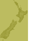
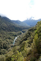 From Te Anau (87km) the Milford Road drops down from the Divide into the Hollyford Valley, which runs 80km from its headwaters to the Tasman Sea at Martins Bay. The 16km Lower Hollyford Road provides access to the Hollyford Track and the Lake Marion walk, plus a few other diversions. The only habitation is 8km along the valley road at Gunn’s Camp (Hollyford Motor Camp). The road runs 8km beyond the Hollyford Camp to the Road End the beginning of the Hollyford Track. Its also the start of a shorter walk to Humboldt Falls.
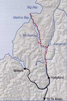 The Hollyford Track is the only major track in Fiordland at low altitude which can be walked in any season. It is 56km, four day (one way, moderate, tramping track from the Hollyford Road end to the old port of Martins Bay.
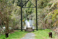 Hidden Falls Hutt to Lake Alabaster Hut, 10.5km, 3-4 hours. The track passes through a section of lowland, then enters tall beech forest before the climb to Little Homer Saddle with views of Mt. Madeline and Fiordland’s highest mountain Mt. Tutoko (2723 metres). The track descends to Little Homer Falls (60 metres) and continues to the Hollyford/Pyke confluence. Continue 20 minutes up the same side of the Pyke River to Lake Alabaster Hut (28 bunks).
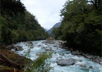 Lake Alabaster Hut to Demon Trail Hut, 14.7km, 4-5 hours. This section of the track is maintained to a lower standard. There can be treefalls which may obscure the track. Watch for orange markers on the trees.